ISO 3166-2:IN
| # |
[agm] |
ISO 3166-2 |
州名 |
現地名 |
備考 |
|
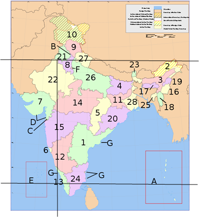
| 1 |
B34 |
IN-CH |
チャンディーガル連邦直轄地域 |
Chandi-garh |
B on the MAP |
| 2 |
B34 |
IN-HP |
ヒマーチャル・プラデーシュ州 |
Hima-chal Pradesh |
#9 on the MAP |
| 3 |
B34 |
IN-JK |
ジャンムー・カシミール州 |
Jammu and Kashmi-r |
#10 on the MAP |
| 4 |
B34 |
IN-PB |
パンジャーブ州 |
Punjab |
#21 on the MAP |
| 5 |
B34 |
IN-UL |
ウッタラーカンド州 |
Uttaranchal |
#27 on the MAP |
| 6 |
B45 |
IN-DD |
ダマン・ディーウ連邦直轄地域 |
Dama-n and Diu |
D on the MAP |
| 7 |
B45 |
IN-DN |
ダードラー及びナガル・ハヴェーリー連邦直轄地域 |
Dadra and Nagar Haveli |
C on the MAP |
| 8 |
B45 |
IN-GA |
ゴア州 |
Goa |
#6 on the MAP |
| 9 |
B45 |
IN-GJ |
グジャラート州 |
Gujara-t |
#7 on the MAP |
| 10 |
B45 |
IN-LD |
ラクシャディープ諸島 |
Lakshadweep |
E on the MAP |
| 11 |
B45 |
IN-MH |
マハラシュトラ州 |
Maha-ra-shtra |
#15 on the MAP |
| 12 |
B46 |
IN-AN |
アンダマン・ニコバル諸島 |
Andaman and Nicobar Islands |
A on the MAP |
| 13 |
B46 |
IN-AP |
アーンドラ・プラデーシュ州 |
Andhra Pradesh |
#1 on the MAP |
| 14 |
B46 |
IN-AR |
アルナーチャル・プラデーシュ州 |
Aruna-chal Pradesh |
#2 on the MAP |
| 15 |
B46 |
IN-AS |
アッサム州 |
Assam |
#3 on the MAP |
| 16 |
B46 |
IN-BR |
ビハール州 |
Biha-r |
#4 on the MAP |
| 17 |
B46 |
IN-CT |
チャッティースガル州 |
Chhatti-sgarh |
#5 on the MAP |
| 18 |
B46 |
IN-DL |
デリー首都圏 |
Delhi |
F on the MAP |
| 19 |
B46 |
IN-HR |
ハリヤーナー州 |
Harya-na |
#8 on the MAP |
| 20 |
B46 |
IN-JH |
ジャールカンド州 |
Jharkhand |
#11 on the MAP |
| 21 |
B46 |
IN-KA |
カルナータカ州 |
Karna-taka |
#12 on the MAP |
| 22 |
B46 |
IN-ML |
メーガーラヤ州 |
Megha-laya |
#17 on the MAP |
| 23 |
B46 |
IN-MN |
マニプル州 |
Manipur |
#16 on the MAP |
| 24 |
B46 |
IN-MP |
マディヤ・プラデーシュ州 |
Madhya Pradesh |
#14 on the MAP |
| 25 |
B46 |
IN-MZ |
ミゾラム州 |
Mizoram |
#18 on the MAP |
| 26 |
B46 |
IN-NL |
ナガランド州 |
Na-ga-land |
#19 on the MAP |
| 27 |
B46 |
IN-OR |
オリッサ州 |
Orissa |
#20 on the MAP |
| 28 |
B46 |
IN-PY |
パーンディッチェーリ連邦直轄州 |
Pondicherry |
#G on the MAP |
| 29 |
B46 |
IN-RJ |
ラージャスターン州 |
Ra-jastha-n |
#22 on the MAP |
| 30 |
B46 |
IN-SK |
シッキム州 |
Sikkim |
#23 on the MAP |
| 31 |
B46 |
IN-TN |
タミル・ナードゥ州 |
Tamil Na-du |
#24 on the MAP |
| 32 |
B46 |
IN-TR |
トリプラ州 |
Tripura |
#25 on the MAP |
| 33 |
B46 |
IN-UP |
ウッタル・プラデーシュ州 |
UttarPradesh |
#26 on the MAP |
| 34 |
B46 |
IN-WB |
西ベンガル州 |
West Bengal |
#28 on the MAP |
35 |
B56 |
IN-KL |
ケーララ州 |
Kerala |
#13 on the MAP |
|