ISO 3166-2:FR
| # |
[agm] |
ISO 3166-2 |
州名 |
現地名 |
備考 |
|
| 1 |
B21 |
FR-O |
ノール=パ・ド・カレー |
Nord-Pas-de-Calais |
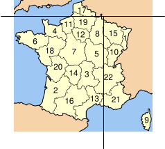
#17 on the MAP |
| 2 |
B31 |
FR-B |
アキテーヌ |
Aquitaine |
#2 on the MAP |
| 3 |
B31 |
FR-C |
オーヴェルニュ |
Auvergne |
#3 on the MAP |
| 4 |
B31 |
FR-D |
ブルゴーニュ |
Bourgogne |
#5 on the MAP |
| 5 |
B31 |
FR-E |
ブルターニュ |
Bretagne |
#6 on the MAP |
| 6 |
B31 |
FR-F |
サントル |
Centre |
#7 on the MAP |
| 7 |
B31 |
FR-G |
シャンパーニュ=アルデンヌ |
Champagne-Ardenne |
#8 on the MAP |
| 8 |
B31 |
FR-J |
イル=ド=フランス |
Ile-de-France |
#12 on the MAP |
| 9 |
B31 |
FR-K |
ラングドック=ルシヨン |
Languedoc-Roussillon |
#13 on the MAP |
| 10 |
B31 |
FR-L |
リムーザン |
Limousin |
#14 on the MAP |
| 11 |
B31 |
FR-N |
ミディ=ピレネー |
Midi-Pyrenees |
#16 on the MAP |
| 12 |
B31 |
FR-P |
バス=ノルマンディー |
Basse-Normandie |
#4 on the MAP |
| 13 |
B31 |
FR-Q |
オート=ノルマンディー |
Haute-Normandie |
#11 on the MAP |
| 14 |
B31 |
FR-R |
ペイ・ド・ラ・ロワール |
Pays de la Loire |
#18 on the MAP |
| 15 |
B31 |
FR-S |
ピカルディ |
Picardie |
#19 on the MAP |
| 16 |
B31 |
FR-T |
ポワトゥー=シャラント |
Poitou-Charentes |
#20 on the MAP |
| 17 |
B31 |
FR-V |
ローヌ=アルプ |
Rhone-Alpes |
#22 on the MAP |
| 18 |
B32 |
FR-A |
アルザス |
Alsace |
#1 on the MAP |
| 19 |
B32 |
FR-H |
コルス(コルス地方公共団体)(コルシカ島) |
Corse |
#9 on the MAP |
| 20 |
B32 |
FR-I |
フランシュ=コンテ |
Franche-Comte |
#10 on the MAP |
| 21 |
B32 |
FR-M |
ロレーヌ |
Lorraine |
#15 on the MAP |
| 22 |
B32 |
FR-U |
プロヴァンス=アルプ=コート・ダジュール |
Provence-Alpes-Cote d'Azur |
#21 on the MAP |
|